Despite a summer ridden with interrupted plans and canceled internships, four William & Mary students decided to make the most out of their summer by researching how COVID-19 has affected local environments around the world. All members of the geoLab, Emily Maison ’21, Joshua Panganiban ’20, Tina Chen ’22, and Laura Mills ’22 interned for the Global Environment Facility, where they independently collected and analyzed geospatial data.
The Global Environment Facility, commonly referred to as the GEF, is an organization that tackles pressing environmental issues and supports community-based and national sustainable development initiatives. In past years, students from the geoLab have worked with the GEF and have co-authored research papers for the organization.
“Moving towards the spring, the GEF offered more opportunities for conducting impactful international research,” Panganiban said. “And that led to the proposal of having four virtual internships related to the environment and GEF mission.”
Beginning in June, Maison, Panganiban, Chen, and Mills researched their four different projects for 40 hours a week. Though under the guidance of GEF, each student was required to pace and manage themselves, only meeting with GEF leadership once per week.
Maison–a recent graduate of the college–worked as the Assistant Program Manager for the geoParsing team’s BRIGHT project. For her summer research project, she worked on a literature review regarding the consequences of human encroachment on natural resources and how these unnatural conditions will lead to more infectious disease outbreaks.
“I applied to GEF to research COVID-19 because the semester before I did labor market research on the implications of COVID on health care access,” Maison said. “I wanted to take a different approach and further my understanding of the pandemic, and I think my work this summer did that. I loved doing the internship. It was enjoyable to lead my own research, as well as meet other people across different teams in the lab.”
Maison believes the knowledge she gained during this internship helped her improve her research on the geoLab’s BRIGHT project.
“I learned a lot about sustainable development goals from the UN, as well as the implications of different environmental interventions,” Maison said. “My research definitely helped me expand my knowledge on sustainability, as well as what contracting for another organization looks like.”
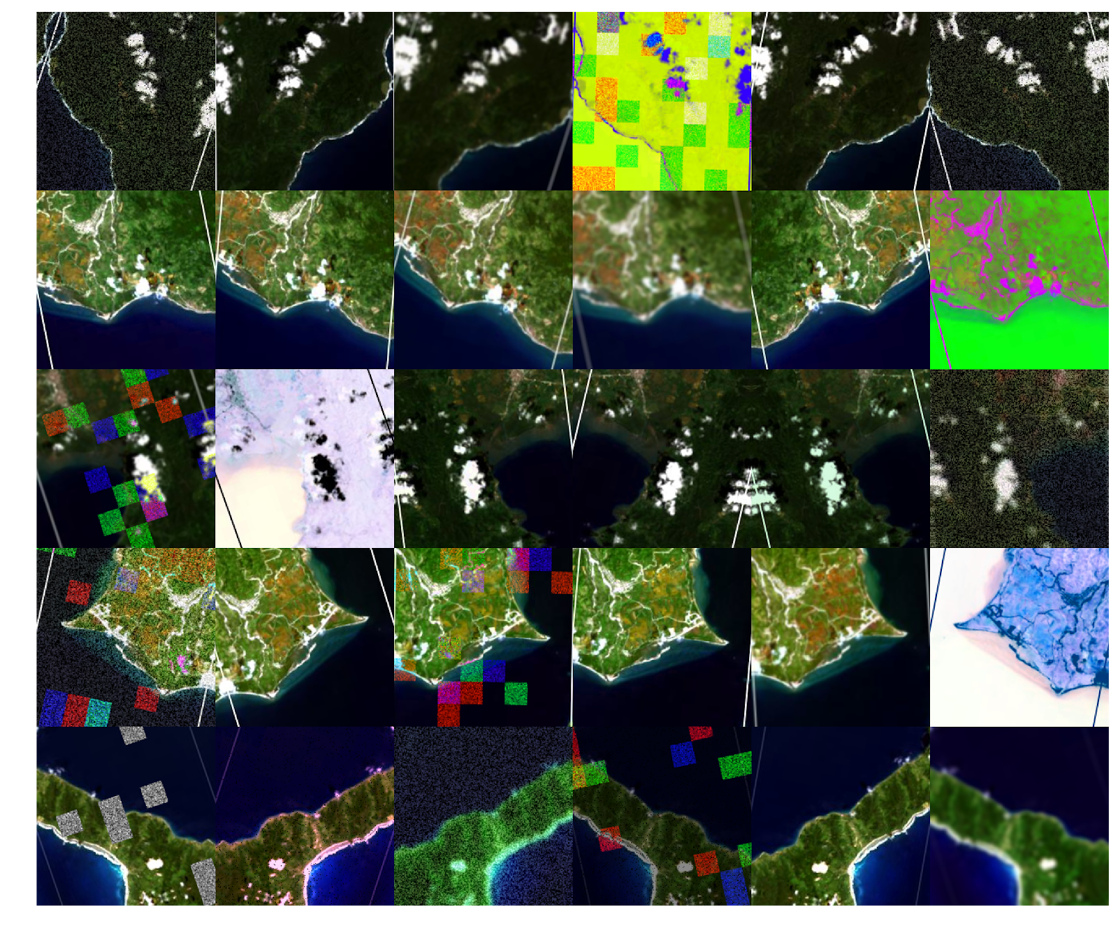
Mills currently works as an analyst for the geoData team and says she was excited to have an internship that revolved around the impacts of COVID-19. Her research utilized satellite imagery and forest change remote sensing data to study the impacts of the COVID-19 pandemic on land degradation and biodiversity.
“I looked at areas specifically within the Democratic Republic of Congo. Along with Brazil and Indonesia, the DRC was a top country in the world for deforestation as of March 2020,” Mills said. “As countries began focusing on lockdown restrictions at the start of COVID, deforestation occurred with decreased regulation. So even as people stay inside, protected areas are at risk of illegal mining and forest clearing.”
In order for Mills to track the high levels of deforestation in the Democratic Republic of Congo (DRC), she learned JavaScript and time series modeling in R over the summer. Prior, Mills had only ever coded in Python.
“It completely changed the way that I worked as a data scientist, and it made me so much more comfortable for classes and other geoLab projects this year,” Mills said. “My experience was just something I feel I would never get in a class.”
Chen is currently on the geoDev team, where she primarily works on the roadRunner project. Her study aimed to quantify the association between GEF interventions and local health conditions of children under five years in Kenya. Chen’s health measures included looking at rates of diarrhea and lower respiratory problems.
“We use the Health Survey data as well as the GPS data,” Chen said. “Then, I put them into a spatial statistical model called QGI, which was developed by Dr. Dan Runfola. And, through that model, we were able to tell the magnitude of the association and also how far away the impact could be. So in the end, we were able to make some recommendations to GEF to help them understand how their projects can impact not only the direct metrics, like the biodiversity or vegetations, but also the socio-economic and health aspect of their projects.”
Chen says she enjoyed being able to use the material she learned in her statistics classes and apply it to real-world problems.
“I learned a lot along the way,” Chen said. “Because in stats classes, you’re just looking at toy models, but in the real world models, there could be a lot of unexpected things happening there. I’m happy to see I’m involved in a project that could have some real-world impact.”
Panganiban, who graduated last Spring, was the former team lead for geoBoundaries but is now working as an accountant at Deloitte. His research analyzed satellite imagery and ancillary data to evaluate the impact of the GEF’s biodiversity projects in the Philippines for the past decades.
Panganiban collected data on the area’s biodiversity by using two metrics: a vegetation index that measured terrestrial biodiversity and fishing catch rates.
“If an area is increasing in fish catch, that means that factors supporting fish are increasing, such as productivity, algae growth, and high amounts of food. If the fish catch is high, then the ecosystem is probably pretty healthy,” Panganiban said. “This was only an analysis based on available data, which is why the interviews with executing agency officials were conducted to verify whether what we’re studying from satellites verifies what’s on the ground. That was the most interesting part.”
Panganiban conducted interviews with Filipino government officials in order to further his collection of data and monitor local sites. With the nation in lockdown, all the interviews were conducted virtually.
“One of the coolest things that I think I ever got to do was hop on Zoom calls and talk with officials from the Department of Environmental Natural Resources and seniors in NGO from different islands who are working remotely,” Panganiban said. “I was pretty much doing the same thing that someone in the Philippines would do, except I’m in the United States.”
In October, each student presented their research over Zoom to members of GEF and the head of the geoLab, Assistant Professor of Applied Science Dan Runfola. Much of the data they collected will be used in GEF’s future reports and papers.
“I think the most important part of that meeting, for me, was talking with people at the GEF about how our findings can impact future studies,” Mills said. “For example, I detected land degradation in one of the protected areas I analyzed. So, I explained that I thought it made sense to go in and do further on-the-ground evaluation to distinguish between seasonal land change versus something more abrupt like deforestation. And they agreed with that. We looked at satellite imagery and saw visual proof of potential deforestation.”
For the upcoming year, Maison, Mills, and Chen hope to use their acquired research skills and collected data to aid with future geoLab projects. All four students praised the geoLab for providing this opportunity, and Chen noted how appreciative she was to have a virtual internship for the summer when she originally expected to be unemployed.
“I think one important thing to note about the geoLab is that if you’re a passionate student, it will always find an opportunity for you,” Panganiban said. “Giving students the opportunity to see their work be used by a large international organization is truly the best gift we can offer.”